Erosion of rural, habitat, and agricultural land to sprawl threatens to undo the promise of the General Plan, adopted in 2003, to provide certainty for both open space and development.
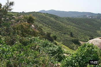
With its history of unmanaged growth in mind, Riverside County’s elected leaders put in place two fundamental reforms in 2003. The first was the Multiple Species Habitat Conservation Plan (MSHCP), now slowly being assembled. The second was to implement a vision for the County’s future through a stable land use map. The “foundations” of the map – Rural and Community Development – can only be converted to another category for compelling planning reasons at comprehensive, 5-year intervals. This is the “Certainty System.” Maintaining the integrity of rural areas, and making good use of existing urban land before creating more, are the challenges facing the County during this first update cycle.
The update process is complicated, consisting of a package of County-initiated changes as well as 140 changes being sought by individual landowners. The landowner track is disconnected from the County track, and also suffers from a lack of organized stakeholder input. And thus far, the staff recommendations and Board of Supervisor actions have been flawed, poking large holes in some rural locations and green-lighting thousands of acres of greenhouse gas emitting sprawl in the Coachella Valley. Also ominous are possible “Rural Village Overlays” that would bring leapfrog development into important wildlife areas.
While the 2003 General Plan was imperfect, maintaining its foundations is the best hope for orderly growth and preservation of scenic landscapes. To improve the outcome EHL is conferring with Board offices, attending committee meetings, and providing detailed comments on proposed actions.